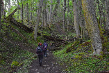
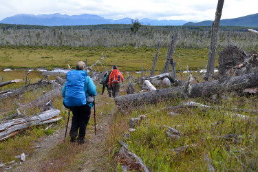
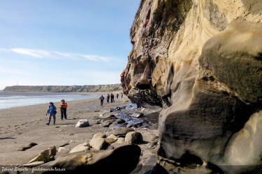
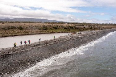
Explore the island in all its magnificent variety of landscapes and enjoy hiking through forests, coasts, mountains and steppes. The trails of the end of the world are waiting for you.
The natural scenery of Tierra del Fuego invites you to walk its trails through forests, valleys and steppes, or along lakes, coasts and mountains.
We offer you a listing of trails to explore, so you can capture in your camera and memory the most spectacular landscapes of the island.
Hiking recommendations
- Careful planning. It’s important to know the information about the trail, its lenght, level of difficulty and current condition. It’s advisable to download a hiking app. You can download suggested trails HERE
- Choose hiking trails that match your level of fitness.Never go hiking alone, you may need someone to asist you in case of an emergency.
- Start your hike as early as possible. Daylight it’s very important to guarantee a safe return.
- Check the weather conditions. Tierra del Fuego’s weather is very unstable all year round.
- Wear waterproof hiking/trekking footwear, with a sole that provides a good grip.
- Dress in layers, with waterproof, insulated jackets and breathable thermal clothing.
- Bring a backpack with a first aid kit, water, food, extra layers, sunglasses, sunscreen, map, compass or GPS device, small pocket knife or multi-tool, flashlight with fresh batteries or headlamp, a garbage bag and a emergency thermal blanket.
- Follow the signs and stick to marked routes.
- Campfires are allowed in designated fire areas only. Check the listing here.
- Collect your litter and bring it back with you.
We suggest hiring the services of a Travel Agency or adventure tourism operators, to avoid any inconveniences on demanding and difficult hikes.
In case of emergency, call 103.
In the Tierra Mayor Valley, you can cross the peat bog to enter a forest with a beautiful foliage of lengas and ñires. When the treeline opens up, the emerald color takes over your view. There lies the famous lagoon of green waters, surrounded by the Andean mountain range.
In the heights of Ushuaia, just 7 kilometers from downtown, you can ascend to the Martial Glacier in a 40/50 minutes trekking. At the end of the signed trail, you can see the mass of ice located at the top of the mountain. If you wish to explore the glacier, you can do this trekking with an authorized guide. Another recommended trail in this area, and where you can get excellent panoramic views of Ushuaia and the Beagle Channel, is the Filo trail.
In Tierra del Fuego National Park you can explore the coastal path along the west bank of the Beagle Channel. In the dense forest of this area there is an abundance of cinnamon trees, notros and michay. The end of the trail leads to Route 3, from where you can access Acigami/Roca Lake or continue to where the road ends at Bahía Lapataia. In this area you can find the Alakush Visitor Center that has a resting place, gastronomy service and bathrooms.
In the center of the island, the ecotone invites you to walk through its lenga forests, lakes and peat bogs. Among the most outstanding sites are the Laguna Negra, the imposing Fagnano Lake, and the Provincial Reserve "Corazón de la Isla" (Heart of the Island).
To the north, you can contemplate the waves of the South Atlantic and San Sebastián Bay. Touring its coasts gives you the opportunity to admire the flight of hundreds of migratory birds and enjoy a vast horizon where the sunset descends over the steppe and the sea with deep skies.
Tierra del Fuego offers endless options for hiking at the End of the World.
Hiking-Important information
In certain mountain areas there are ice caves beneath the glaciers. Attractive as they may be, entering these caves is strictly forbidden for safety reasons. Ice and rocks may fall from the ceiling at any time. Scientists are monitoring the glaciers of the province and have warned about the danger of venturing inside the ice caves. Hikers are reminded to stay on the trail and follow the warning signs.
Activities
Hiking and trekking
Explore the island in all its magnificent variety of landscapes and enjoy hiking through forests, coasts, mountains and steppes. The trails of the end of the world are waiting for you.
The natural scenery of Tierra del Fuego invites you to walk its trails through forests, valleys and steppes, or along lakes, coasts and mountains.
We offer you a listing of trails to explore, so you can capture in your camera and memory the most spectacular landscapes of the island.
Hiking recommendations
- Careful planning. It’s important to know the information about the trail, its lenght, level of difficulty and current condition. It’s advisable to download a hiking app. You can download suggested trails HERE
- Choose hiking trails that match your level of fitness.Never go hiking alone, you may need someone to asist you in case of an emergency.
- Start your hike as early as possible. Daylight it’s very important to guarantee a safe return.
- Check the weather conditions. Tierra del Fuego’s weather is very unstable all year round.
- Wear waterproof hiking/trekking footwear, with a sole that provides a good grip.
- Dress in layers, with waterproof, insulated jackets and breathable thermal clothing.
- Bring a backpack with a first aid kit, water, food, extra layers, sunglasses, sunscreen, map, compass or GPS device, small pocket knife or multi-tool, flashlight with fresh batteries or headlamp, a garbage bag and a emergency thermal blanket.
- Follow the signs and stick to marked routes.
- Campfires are allowed in designated fire areas only. Check the listing here.
- Collect your litter and bring it back with you.
We suggest hiring the services of a Travel Agency or adventure tourism operators, to avoid any inconveniences on demanding and difficult hikes.
In case of emergency, call 103.
In the Tierra Mayor Valley, you can cross the peat bog to enter a forest with a beautiful foliage of lengas and ñires. When the treeline opens up, the emerald color takes over your view. There lies the famous lagoon of green waters, surrounded by the Andean mountain range.
In the heights of Ushuaia, just 7 kilometers from downtown, you can ascend to the Martial Glacier in a 40/50 minutes trekking. At the end of the signed trail, you can see the mass of ice located at the top of the mountain. If you wish to explore the glacier, you can do this trekking with an authorized guide. Another recommended trail in this area, and where you can get excellent panoramic views of Ushuaia and the Beagle Channel, is the Filo trail.
In Tierra del Fuego National Park you can explore the coastal path along the west bank of the Beagle Channel. In the dense forest of this area there is an abundance of cinnamon trees, notros and michay. The end of the trail leads to Route 3, from where you can access Acigami/Roca Lake or continue to where the road ends at Bahía Lapataia. In this area you can find the Alakush Visitor Center that has a resting place, gastronomy service and bathrooms.
In the center of the island, the ecotone invites you to walk through its lenga forests, lakes and peat bogs. Among the most outstanding sites are the Laguna Negra, the imposing Fagnano Lake, and the Provincial Reserve "Corazón de la Isla" (Heart of the Island).
To the north, you can contemplate the waves of the South Atlantic and San Sebastián Bay. Touring its coasts gives you the opportunity to admire the flight of hundreds of migratory birds and enjoy a vast horizon where the sunset descends over the steppe and the sea with deep skies.
Tierra del Fuego offers endless options for hiking at the End of the World.
Hiking-Important information
In certain mountain areas there are ice caves beneath the glaciers. Attractive as they may be, entering these caves is strictly forbidden for safety reasons. Ice and rocks may fall from the ceiling at any time. Scientists are monitoring the glaciers of the province and have warned about the danger of venturing inside the ice caves. Hikers are reminded to stay on the trail and follow the warning signs.


